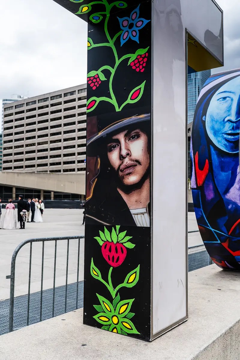
David French Lane is a small lane running between Borden Street and Brunswick Avenue, just south of Bloor Street West:
David French was a Canadian playwright and author of many award-winning plays including “Leaving Home”, “Of The Fields Lately”, “Salt-Water Moon” and “Jitters”. In his honour, the David French Lane was so named in 2014. The lane now hosts some incredible artwork, painted on the fences and garages of the area:
As part of the massive project to revitalize the Toronto waterfront, a total of four new arch bridges have been built in the Port Lands. These bridges will protect the area from flooding, create a naturalized mouth for the Don River, and connect the future Villiers Island (now officially named Ookwemin Minising) to downtown Toronto. These are much-needed changes for our waterfront:
The currently underused industrial area will be transformed into the vibrant and resilient downtown neighbourhood of Villiers Island/Ookwemin Minising. The master plan is to make it a community with housing, parks and a range of transportation options.
I had not been down into this area for quite a while, so I was interested in seeing the new bridges and multiple changes that have so far been put in place.
The Commissioners Street Bridge
Opened in January 2024, the Commissioners Street Bridge is part of Waterfront Toronto’s $1.3 billion revitalization project. This bridge, as well as the Cherry Street North bridge, provides access to all manner of vehicles. It also includes future streetcar routes to the new Villiers Island neighbourhood.
Designed by Entuitive, schlaich bergermann partner (sbp), and Grimshaw Architects, completion of all the bridges is a key component of the Waterfront Toronto’s Port Lands Flood Protection Enabling Infrastructure (PLFPEI) project, which aims to transform 500 acres of previously underused land into a thriving urban space.
According to urbantoronto.ca, the new bridge designs… have earned North American and European accolades including recognition by the Institution of Structural Engineers and the National Council of Structural Engineers Associations. Their sleek, flowing curves are visually compelling and incorporate a hybrid shell-arch structure, optimizing material efficiency and adapting to the unique environmental and foundational challenges of the area.
The Commissioners Street Bridge is the longest of all the new bridges.
Cherry Street South Bridge
This new yellow and white bridge opened in January 2024. It enhances accessibility along the waterfront and serves both vehicle and pedestrian traffic. The bridge features modern engineering reflecting the city’s commitment to improving transportation:
The new Cherry Street South bridge carries the realigned street of the same name over the future mouth of a rerouted Don River now being carved out through the Port Lands, at what is now the Polson Slip, just north of Polson Street.
Cherry Street Strauss Trunnion Bascule Bridge
This is the last of the “old” bridges on Cherry Street, but it’s doubtful it will ever be replaced due to its unique function. It is a Bascule bridge, meaning the structure has the ability to pivot to a vertical position so that ships may pass through the Toronto Harbour Ship Channel below. The bridge has 750-ton concrete counterweights that assist in this lifting function (the white segments on each side of the bridge in the shot below):
This bridge was built in 1930 by the company of Joseph Strauss and the Dominion Bridge Company. Toronto Mayor William Stewart officially opened the bridge on June 29, 1931.
This Bascule bridge was listed under the Ontario Heritage Act by the City of Toronto in 1992 as architecturally historical.
Cherry Street North Bridge
Another of the new bridges. This one is on the newly aligned Cherry Street, spanning the Keating Channel. The left bridge is intended for vehicles, bikes and pedestrians, while the smaller one will be dedicated to future LRT:
This bridge had a mostly-Canadian development, being produced in Dartmouth, Nova Scotia. In October 2020 it left Dartmouth by barge and travelled along the St. Lawrence Seaway to Toronto. The bridge foundations had already been completed, ready for the arrival. When the barge arrived in Toronto’s Inner Harbour, the prefabricated steel superstructure was placed on the completed foundations, and crews then completed the installation.
This will be an active transportation bridge connecting downtown to the new island, Ookwemin Minising, and Biidaasige Park. Anticipated to open in mid-2028, the bridge will provide a vital connection and stand as a gateway to Toronto’s next chapter of waterfront revitalization.
The bridge features a signature “S” shaped suspended arch bridge connected by an array of fanning cables that evokes the sun’s path during solstices and equinoxes, creating a dynamic experience that changes with each step and season.
This project is a partnership between Waterfront Toronto and the City of Toronto, in collaboration with Host Nation and Treaty Holder, the Mississaugas of the Credit First Nation (MCFN).
Canoe Landing Park is an 8-acre urban park in downtown Toronto, adjacent to the Gardiner Expressway in the CityPlace neighbourhood. Situated at 95 Fort York Boulevard, the park serves CityPlace’s high-density community.
Officially opened on September 9, 2009, the park was developed as part of the surrounding condo development and serves as a green oasis in this area’s urban landscape.
The park has a man-made promontory overlooking the Gardiner Expressway, created by 20,000-25,000 dump truck-loads of earth diverted from landfills. This small hill has an elevation allowing viewers to see over the Gardiner Expressway to Lake Ontario if they stand in the red canoe.
The Red Canoe
The park has stand-alone art pieces created by Douglas Coupland, including a canoe large enough for people to stand in, and a colourful display of large fishing bobbers. Unfortunately, the red canoe, which was the centrepiece of the park, was burned in an act of arson on April 2, 2025.
Thankfully I took a few shots of the infamous red canoe – entitled Tom Thomson’s Canoe – prior to its destruction:
Fishing Bobbers
The fishing bobbers are collectively known as Bobber Plaza. In addition to the now-torched canoe, the bobbers were also created by Douglas Coupland as part of the park’s public art installations. The bobbers are designed to reference nearby Lake Ontario to create a sense of “futuristic Canadian energy”:
Terry Fox Memorial
This installation in Canoe Landing serves as a permanent, reflective memorial in the heart of the community, contrasting the mundane with the extraordinary sacrifice of Terry Fox’s journey. The park also hosts the annual CityPlace Terry Fox Run, featuring a 5-kilometre route.
As the plaque below explains, this bottle of champagne was to have been used to toast Terry on the evening he received the Order of Canada. Rather than opening it that night, Terry’s mother, Betty, decided she would open the bottle only when a cure is found for cancer:
The park has the “Terry Fox Miracle Mile”, which loops around the Canoe Landing park; doing two loops of the site equates to one mile.
Terry ran a total of 5,373 kilometres (3,339 miles) over 143 days, averaging about 42 kilometres (26 miles) per day, through the Maritimes, Quebec and Ontario.
I had never heard of the Rosehill Reservoir until I started doing a little research on an interesting sculpture located there.
The Rosehill Reservoir sits beside Rosehill Avenue, east of Yonge Street, and is part of the David A. Balfour park:
The Reservoir was created in 1874 to supply clean drinking water to the residents of Toronto, and continues serving this function to the present day. The underground Reservoir stores 270 million litres of drinking water.
The Days of the Open Reservoir
These shots from the Toronto City Archives show how the Reservoir looked circa 1930s, prior to its being covered and landscaped:
The Great Cover-up
In the early 1960s the City of Toronto covered over the then-open top of the Reservoir. This was done for a number of reasons: maintenance and cleanliness obviously, but at the time there was a fear that spy satellites (which could clearly see the Reservoir from space) could enable enemy agents to poison Toronto’s water supply.
The completion of the Reservoir covering fell at the same time as Canada’s 1967 Centennial celebrations. As such, the landscaping on top of the Reservoir was treated as a Centennial project, and an appropriate plaque was installed in the new park:
Centennial plaque on the “Water Molecule” sculpture
The park’s water molecule sculpture (entitled – wait for it – Water Molecule) is a representation of the basic molecular structure of water (H2O). The oxygen atoms are represented by the spheres and the hydrogen atoms appear as the connecting rods:
Renovations
In 2020 the park closed to undergo major renovations by the City of Toronto. The park partially reopened in November 2022, with an official full re-opening in spring 2023.
In addition to repairs and upgrades to the reservoir and water systems, the upgrades removed the fountains and ponds which were the main feature of the park previously, but saved the Water Molecule sculpture.
The new park features a ring trail around the park and two shady pergolas. At the northeast corner of the park the public bathroom facilities were renovated and upgraded.
The City of Toronto website lists the following park enhancements of the most recent renovation:
Re-designed park entrance on Rosehill Avenue
Expanded gardens, including a community flower garden cared for by local community volunteers
More than 250 newly planted trees and shrubs
New, accessible multi-use trails
New washrooms
Two new seasonal water fountains with dog bowls
New lighting on all paths for improved accessibility and safety
Additional benches and picnic tables
New artwork throughout, such as larger water valves and repositioned and enhanced heritage water feature (the water molecule)
New historical plaques
New community lending library
In 2021 the Water Molecule sculpture was moved from the centre of the park to a more visible location overlooking Rosehill Avenue.
The washroom building
Looking south
Valve House for reservoir
A fragment of an old Reservoir pipe, now serving as a sculpture
The Rosehill Garden
Instigated and created by local residents, the Rosehill Garden in the Park adds a bit of colour (and plenty of dandelions by the look of it…) to the expanse:
The north side of the Reservoir, taken while walking along Rosehill Avenue. The park surface clearly rises over the reservoir.
Here is a very interesting (and short) CBC video on this so-called “Hidden Toronto Spot”:
Gillie and Marc Schattner are a British and Australian collaborative artist couple. Gillie and Marc are known for their animal, human-animal hybrid and abstract sculptures, which have been exhibited as public works of art in more than 250 cities worldwide.
The pair’s art is their way of bringing awareness to the plight of animal welfare in many countries, especially Africa. Gillie and Marc describe themselves as “Eco-Warrior Artists Using Love and Art to Save Wildlife”:
Our unifying mission is to fill the world with inspiring public art that spreads messages of love, equality, conservation and hope. As public sculpture artists and wildlife activists, our method is to put wildlife front and centre in cities across the planet, making unforgettable experiences and recreating connections with the wild world. We aim to inspire a community that passionately works for change and unity so we can all live in a better world tomorrow.
At the moment, the following two Gillie and Marc sculptures are on display in Toronto, although I believe the Yorkville one may be gone by now.
Sculpture 1: He Was On A Wild Ride To A Safer Place With Rabbitwoman and Dogman
Located at David Pecaut Square, beside Metro Hall on King Street West
From the sculpture’s description:
“Together with Rabbitwoman and Dogman , this wacky, wild crew are in search of safety. This white rhino is threatened by endangerment, mainly from poaching and habitat loss. His only chance of survival is if everyone comes together, lending their peddling power to save all species.”
“Rabbitwoman and Dogman tell the autobiographical tale of two opposites coming together as best friends and soulmates. This beloved pair of characters work as our conduit with wildlife, helping us find joy in nature and rekindle our connection with the wild. In the last 50 years, 70% of the planet’s wildlife has been lost. We must act now to save them. Share your own photo with the hashtag #LoveTheLast and join the campaign for conservation”.
Sculpture 2: Table Of Love
Located at 120 Scollard Street in Yorkville
From the sculpture’s description:
Even Though It Was Their First Date,He Asked Her to Marry Him. And She Said YES
“They say when you know, you know, and Dogman and Rabbitwoman both did after just one date. They met, they had dinner, he asked, she said yes. And within a week of first meeting each other they were in Nepal getting married in the foothills of Mount Everest. They still love going on dates together, sharing food, laughter and conversation. And after all this time – to adventure, to chance, to each other – they always say yes.”
Gillie and Marc have an amazing, interesting and very extensive website, located here.
Everyone knows our famous TORONTO sign in Nathan Phillips Square, but how often have we taken a really close look at it? I hadn’t, until now. The current “wrap” (as these designs are called) has been in place since September of 2022; I’ve seen it so many times it’s burned into my memory, and I’ve taken the sign for granted without really looking closely at it.
I just learned that the City of Toronto will soon be removing the wrap and replacing it with a special FIFA World Cup 2026 display, so I thought I’d better grab a few close-up shots before the current wrap disappears forever. On close inspection the wrap reveals some very beautiful artwork.
Our iconic TORONTO sign was originally created for the 2015 Pan American Games as a temporary attraction meant to be dismantled in November 2016, but the City of Toronto decided to continue to operate the sign after it became popular with tourists and residents. A 3D leaf structure was added to the sign in 2017 to mark Canada’s 150th birthday.
The current vinyl wrap is an artwork entitled Rekindle, designed by artist Joseph Sagaj in recognition of UNESCO’s International Decade of Indigenous Languages (2022 to 2032). Joseph Sagaj is Anishnaabe (Ojibwe) of the Sturgeon Clan, from the remote community of Neskantaga, approximately 500 km northeast of Thunder Bay, Ontario.
This 3D Medicine Wheel was installed on June 18, 2018 in honour of Indigenous Peoples and timed to elevate awareness of National Indigenous Peoples Day on June 21 of that year. The Medicine Wheel symbol was chosen as it is an emblem of North American Indigenous cultural values, tradition and spirituality. Its four directions (East, South, West and North) symbolize completeness, wholeness, connectedness and strength.
A Few Fun Facts About the TORONTO Sign*
Each letter can be moved and placed on its own
Each letter is 3 m (10 ft) tall and rests on a weighted plinth (base)
The full word is 22 m (74 ft) long
The weight of the whole sign is 9,207 kg (20,300 lbs)
Each letter weighs approximately 136 kg (300 lbs)
Each letter plinth (base) weighs approximately 1,180 kg (2,600 lbs)
Each letter is equipped with LED lights and can transition to approximately 228 million different colours
The Sign contains approximately 396 m (1,300 ft) of LED lights
The letters are constructed with a steel frame, aluminum cladding and a translucent polycarbonate front and back
The colourful sides are covered in a changeable vinyl wrap, so the letters can be re-skinned with different designs
*Courtesy of the City of Toronto’s Toronto Sign web page
This past Sunday I set off downtown to photograph some architecture for the blog. I was pleasantly waylaid, though, by the Khalsa Day Parade snaking its way through the downtown core.
The Parade Assembles on Bay Street
Khalsa Day is a major Sikh festival celebrating the 1699 establishment of the Khalsa (the Sikh community). It commemorates the birth of the Sikh order, and emphasizes equality, service and commitment. Khalsa is celebrated with parades, hymns, and free food:
This was the first time I’d experienced the Khalsa Festival. I didn’t even know it existed until I literally stumbled upon it. Several friendly Sikhs approached me during the Parade to see if I knew what the celebration was about; they were pleased and proud to tell me about their culture and religion. I was fascinated by all the colour, positivity and sense of community that day.
The Parade headed across King Street West and up University Avenue:
The Sikh faith believes in the Creator 1, which is an Infinite Source all around us and is the Source of everything. With the 1, the human race is all equal. and has the 1’s light within. The 1’s light is free of gender, religion, race, nationality or sexual orientation. Sounds good to me.
The Sikh Motorcycle Club
Khalistan
What is Khalistan? Khalistan (meaning “Land of the Khalsa”) is a proposed independent Sikh sovereign state envisioned for the Punjab region, primarily intended to be carved out of northern India.
Massive Gurdwara at Nathan Phillips Square
Free food for all is a core principle of Sikh Gurdwaras (Sikh Temples). Everyone sits as equals to eat the same food, which is prepared by volunteers.
As the Parade returned to its point of origin – Nathan Phillips Square – huge crowds descended on the Square. Free food to all was provided. To enjoy the food, one needs to cover the head, remove shoes and socks, and wash hands (as best you can outside anyway):
Food was also enjoyed out on Queen Street West. This is in the spirit of Langar: a free, open vegetarian kitchen served to all attendees regardless of background:
As of 2026, Khalsa Day has been celebrated in Toronto for 40 years, with the inaugural parade taking place in 1986.
The Parade and event brought thousands of people into the downtown core. It was fascinating taking in the colour, sounds and culture of the event; it proved to be a great learning experience for yours truly.
Today we’ll take a short, rainy-day walk across Richmond Street West, roughly from Simcoe Street to John Street. Prior to researching it, I knew in general that this street was of historical significance in terms of Toronto’s old warehouse district. Delving a little deeper I learned a bit of background on some of the buildings along this stretch.
The Graphics Art Building – 73 Richmond Street West
These are live-and-work lofts and suites in an historic building with classic architectural details. Built in 1913, the limestone building features Ionic columns and cornice work. For years it was the headquarters of Saturday Night Magazine, an esteemed publication that featured the writing of many of Canada’s most acclaimed writers including Stephen Leacock, John McCrae, Robertson Davies and Margaret Atwood. The entrance still boasts the original Saturday Night signage.
The CHUM Studios – 250 Richmond Street West
Corner of Richmond Street West and Duncan Street. This historic 4-storey building on Richmond Street West near Duncan Street serves as the headquarters for iHeartRadio Canada, radio stations—CHUM-FM (104.5), CFRB (Newstalk 1010), and CKFM-FM (99.9 Virgin Radio).
The iconic vertical “CHUM” neon sign was moved from its original location at 1331 Yonge Street. Prior to becoming a Bell Media radio hub, the building was a nightclub venue (home to Go-Go’s and Whiskey Saigon in the late 80s and early 90s). The building achieved heritage significance in 2017, located within the King-Spadina Heritage Conservation District.
The building was constructed circa 1909 amid the area’s second wave of industrialization, which emphasized garment and light manufacturing activities.
RendezViews – 229 Richmond Street West
RendezViews is Toronto’s largest outdoor patio and event space, located at 229 Richmond Street West in the Entertainment District. Known for its vibrant, colourful painted picnic tables and massive murals, this former parking lot was transformed into a popular spot for watching sports, live entertainment, and social gatherings.
RendezViews aerial view. Photo: RendezViews
Reflections Mural – 229 Richmond Street West
Reflections is a massive 45,000-square-foot mural and art experience located at 229 Richmond Street West in Toronto, forming part of the RendezViews patio (see aerial shot above).
This impressive mural was created by artists Clandestinos (which consists of Bruno Smoky and Shalak Attack) in 2021. The mural covers the ground and walls with vibrant, kaleidoscopic colours, telling a story of optimism and community growth.
Tip Top Tailors “Ghost Sign” – 260 Richmond Street West
Located on the west facade of 260 Richmond Street West, east of John Street. Built in 1914/15, this historic World War I-period industrial building is the former warehouse for Tip Top Tailors. Its west-facing ghost sign reads: Home of Tip Top Tailors – Suits & O’Coats Always One Price – To Measure.
Tip Top Tailors was founded in 1909 by David Dunkelman, a Polish-Jewish immigrant. The company moved from this location to 637 Lake Shore Boulevard West in 1929. Today this Richmond Street West site is home to Bell Media.
Gelber Brothers Sign – 217-225 Richmond Street West
Moses and Louis Gelber were two Jewish immigrant brothers, arriving in Toronto in 1896. After each had great success in their ventures, the brothers consolidated their operations at 217-219 Richmond Street West, near Duncan Street. In 1923, they hired well-respected Jewish architect Benjamin Brown to build their warehouse and office building at the current address.
These shots were taken on Richmond Street West behind 299 Queen Street West. The building is the official headquarters of Bell Media (CTV Drama Channel, BNN Bloomberg, CTV Comedy Channel, E!, Oxygen True Crime, CTV Life Channel, Much, etc.).
The current five-storey building was originally constructed in 1913 as the headquarters of the Methodist Church of Canada by the architectural firm of Burke, Horwood and White. The Methodists joined with two other denominations to form the United Church of Canada in 1925, for which the building served as the headquarters until 1959. By this time the Ryerson Press, originally the publishing arm of the Methodist Church, had grown to occupy the entire building.
Post-Rain Reflections – Richmond Street West
WeWork Building – 240 Richmond Street West
This building is home to “WeWork”, a six-floor co-working space in Toronto’s Entertainment District. WeWork offers flexible workspaces, including private offices, dedicated desks and meeting rooms, along with related amenities.
From the company’s website: Across three thoughtfully designed floors, you’ll find private offices, open lounges, and quiet nooks where teams and individuals can focus, meet, and create. Onsite staff, daily cleaning, and high-speed internet keep everything running seamlessly, while phone booths and well-equipped conference rooms make it easy to handle focused calls and client meetings. With bike storage, showers, micro-roasted coffee, and welcoming common areas, this location is built for comfortable workdays and steady energy.
This stretch of Richmond Street West is an interesting part of the downtown. The street is a vital, high-intensity corridor within Toronto’s King-Spadina area, functioning as a nexus for commercial growth and residential density.
Following a tradition that goes back to 1962, the St. Francis of Assisi Parish in Toronto held its annual Good Friday Procession on the streets of Little Italy yesterday, Friday, April 3rd:
The mile-long Procession included religious statues, musical bands, and people representing different characters associated with re-enacting the fourteen Stations of the Cross (Jesus on his way to crucifixion).
The Procession, which has become a sight to behold due to its scale and grandeur alone, has not always been that way, according to current pastor Fr. Massimo Buttigieg:
This was something started by our people back in 1962, and it was originally a simple drama play done in the hall of the parish. They evolved over the years, and it wasn’t until they bought the statue (of the crucifix) that they started the procession with that statue.
Ever since those early days, we have added more statues, volunteers with costumes and different characters from the Passion. Today, we have eight statues in total and around 200 different characters in the street procession.
The Procession started at 3:00PM, but I’ve always found the more interesting shots are not of the Procession itself, but of the event participants getting ready at the St. Francis of Assisi Church, at the corner of Grace Street and Mansfield Avenue.
When I arrived I was surprised to find 30-35 other photographers already on site – paparazzi abounded!


The colours are very vibrant. I love this type of graffiti. It livens up the city. Good work Marvin.