This is a 3-part post focusing on some of the murals and artwork in the Wilson Heights area of the city.
First up are the Wilson subway station murals. These murals are located on Wilson Avenue under the Allen Road underpass, at the south exit of the Wilson subway station. There are 40 pillars of artwork, created by street artist Shalak Attack and her collaborator Bruno Smoky. The colour of the artwork certainly gives a lift to an otherwise drab, depressing part of the city.
North Side of Wilson Avenue
Crossing Wilson Avenue to shoot murals on the south side of the Allen Road underpass, I took this shot to highlight why a bit of colour is appreciated in this part of town
South Side of Wilson Avenue
Next post: Wilson Heights, Part 2: Wilson Station South Exit
On August 19 and 20 the Toronto Chinatown Business Improvement Area hosted its 23rd annual Toronto Chinatown Festival on Spadina Avenue, running from Sullivan Street to College Street.
This year the Festival’s theme was Flaming Phoenix: Rebirth & Uprising, signifying the rebirth of our city after COVID-19. In Chinese mythology, the Phoenix is an immortal bird whose rare appearance is said to be an omen foretelling harmony at the ascent to the throne of a new emperor – the same might be applied to our city as we try to put COVID behind us.
Falun Dafa Parade
Making my way up Spadina Avenue to the Festival, I encountered a parade from the Falun Dafa practitioners. They were supporting the 417 million Chinese people who have withdrawn from the Chinese Communist Party (CCP) and its youth organizations. The parade began at Clarence Park and wound through the streets of Chinatown. As far as I know, this parade was not connected with the Chinatown Festival in any way.
Toronto Chinatown Festival
Moving further north up Spadina Avenue I found the actual Festival. This year’s Festival seemed really scaled back to me and there didn’t seem to be that much of interest to photograph; regardless I found:
Lots of street food…
Plenty of jewellery and clothing vendors…
Magicians…
Singers…
And various street stuff…
Moving out of the Festival area and further down Spadina Avenue, I encountered Saturday afternoon market shoppers:
This post is sort of a companion piece to my last post on Craigleigh Gardens. The quiet and scenic urban trail known as Milkman’s Lane is located off South Drive in Rosedale, next to Craigleigh Gardens.
Though short and steep, the trail connects with the Beltline Trail which leads to the nearby Evergreen Brick Works, Moore Park Ravine and the Lower Don trail system.
Seen on historic maps since at least 1890, the abandoned roadway is 130 years old. It’s been said the pathway was originally intended for mostly commercial transport including, presumably, deliveries of milk.
It’s now a beautiful dirt pathway bordered in by wooden fences and plunging hills on either side as you’re led further into the ravine system. It’s primarily frequented by cyclists, hikers and dog walkers.
The lush vegetation includes black cherry, hemlock, yellow birch, ironwood, the endangered butternut, oak and maple trees.
If you keep following the Park Road Reservation Trail west at the bottom of the ravine, you’ll be offered up pretty views of Yellow Creek as it flows by.
For this TOcityscape we’ll head to the west of the city and take a look at Islington Village and the beautiful, historic murals there. The Islington Village murals run along Dundas Street West from Islington Avenue to Kipling Avenue:
In 2004 the Islington Business Improvement Area (BIA) was charged with the responsibility of beautifying and enhancing this part of the city. Over the next few years BIA-appointed artists created many large-scale murals on the sides of the area’s buildings. These beautiful, vivid and detailed murals depict some of the history of the community; to date there are 26 murals covering over 25,000 square feet of public art.
Each of the murals has a descriptive panel mounted beside it, telling the particular history and details of the scene. I have transposed those descriptions to my shots below.
Golfing In Islington
This 7.3 by 7.0 metre mural depicts golf in the 1920s. The Islington Golf Club – designed by Stanley Thompson, one of the foremost golf course architects in North America at the time – is located just minutes from this site.
In the foreground of the mural, golfers dressed in late 1920s fashion enjoy their day on the green. The lead golfer is attempting to hit the ball away from the tree line at the western edge of the course where it landed after an overzealous tee off. The impatience of the group is shared by the small boy and the ball collector. The little boy has found distraction in a stray frog, and the ball collector – wearing upper body protective gear – is waiting for the group to play through so he may resume his duties.
Aftermath
Hurricane Hazel struck Toronto on October 15, 1954. In her wake most of the Islington Golf Course and low-lying areas near Mimico Creek were flooded. This mural shows a volunteer clean-up crew arriving at the scene as a member of the Islington Fire Brigade helps moor their boat. Behind them, members of the 48th Highlanders are clearing away the debris. Above, an army supply helicopter prepares to use the 9th fairway, then high ground, as a landing strip. Islington United Church, which became a makeshift supply depot for the whole region, is visible on the horizon (near top left).
The Manse Committee
This mural shows the interior of this Dundas Street West building as it might have appeared around 1888. At that time it was the manse, or minister’s residence, for Islington’s Wesleyan Methodist Church.
The scene is a light-hearted portrayal of “The Manse Committee” which advised the minister’s wife on décor and conducted periodic inspections to make sure the residence was kept acceptably clean. Reverend Richard Bowles, who later became the Chancellor of Victoria University, is shown having tea with the Committee Chair while his wife prepares food in the kitchen and Committee members conduct a white gloved inspection of the premises.
The mural depicts a typical late Victorian residence with furniture that would have been available in Toronto in the 1880s. The floor plan, construction methods and interior were designed according to building practices at the time.
The Faces Of Islington
This mural celebrates the ethnic and cultural character of Islington as it has changed over the last century. The faces and traditional design patterns of fabrics from all four continents travel along the timeline, telling the story of settlement in the area.
Beyond depicting the passage of history as grandparents, parents, children and grandchildren share the same space, notice the change in Islington from a predominantly Eurocentric community during the 1950s into the ethnically diverse neighbourhood it is today.
Faith Of Our Fathers, 2
This mural depicts the history of Islington United Church from its early Wesleyan Methodist days on Dundas Street West to the building of the church now located at 25 Burnhamthorpe Road.
As early as 1815 circuit riders, ministers on horseback, rode from hamlet to hamlet attending to the spiritual needs of roughly 30 rural communities. The first Methodist Church in the village was located at 4946 Dundas Street. When the congregation outgrew the building, it was sold to the Etobicoke Township. The Township added a red brick façade (shown above) and the building became the Municipal Offices and Police Station. Much altered, it is now the Fox and Fiddle, Precinct.
The circuit rider in the mural has the face of Dr. Stewart East who, along with other ministers as part of the dedication ceremony, rode up the steps of the new church at 25 Burnhampthorpe. This re-enactment created quite a spectacle.
Portraits From Our Past
Inspired by old area photos, Manitoba artist Sarah Collard has created a gallery effect on this 6 metre by 10 metre wall. The mural is actually four separate works, each depicting a “slice of life” from the village’s past. These include:
The Village Shoemaker Mr. Nelson, as he appeared early in the 20th century.Islington’s First Car A 1917 Chevrolet owned by the Appleby familyApple Packers Bigham family orchards ca. 1917
Battersby’s March, 1813
On July 29, 1813, Lieutenant Colonel Francis Battersby was ordered to leave York (Toronto) with all the soldiers under his command to secure Burlington against an imminent American threat. Dispatched in a “march of extraordinary celerity” along Dundas Street, this force, consisting largely of Battersby’s own regiment, the Glengarry Light Infantry, arrived in time to dissuade the enemy from attacking this key position. However, this troop redeployment left York vulnerable, setting the stage for the second American raid on the town on July 31, 1813.
Briarly – Gone But Not Forgotten
Also known as the Gunn house, Briarly was built in the 1840s. Originally a frame Regency style cottage built just east of T. Montgomery’s Inn, it was redesigned in the 1850s to have an Italianate appearance. From 1970 until 1985, the home was owned by the Montgomery family and their descendants.
Although the heritage community lobbied to save the home from demolition, Briarly was demolished by developers in August 1989. Town houses now occupy the site at 4681 Dundas Street West.
This mural, by artist John Kuna was designed not only to illustrate a part of Islington’s history but also to convey a sense of comfort, peace, home and family. Rather than becoming a theme of mourning and end, it is instead conceived as an image of endurance and renewal.
The Pub With No Beer
This mural depicts a scene from the prohibition era (ca. 1928) with a pop truck rounding up empty bottles outside of the old Islington Hotel, which was once a local watering hole. At the time Burnhamthorpe Road was on the west side of the hotel and the hotel’s drive-shed stretched across what is now the intersection of Dundas Street West and Burnhamthorpe Road and Cordova Avenue.
Gordon’s Dairy, ca. 1940
The 3.3 x 7.3 metre mural depicts Gordon’s Dairy, a local landmark once located in this building. The original structure had a yellow-tile front, with a lunch counter and diary bar inside. In the 1940s, Gordon’s Dairy was a popular hang-out for area youth, and the dairy’s horse-drawn milk wagons were a familiar sight on Islington streets.
Ordinary Folk, Extraordinary Lives
This mural commemorates the original founding families of Islington who now rest in the Islington Burying Ground just east of this site, one of the oldest cemeteries in Toronto, dating from the 1840s. While the subject matter is somber, this mural has been infused with light reminiscent of both dusk and dawn to hint at life’s cycle. Six windows remind us of our human vulnerability to the passage of time.
The settler families are depicted in a formal and dignified way to suggest their important and permanent role in the community’s history. The few precious photos that exist of these original families have been incorporated into the mural design, including members of the Montgomery, Death, Shaver, East and Johnston families. Their faces are generally solemn because subjects were required to remain motionless during the early days of photography.
Each family’s headstone is placed to strengthen the composition of the figures and add to their appearance of dignity and gravity. Details of the old tombstones showcase the beauty of their carved emblems and inscriptions. Today, most of the original tombstones have been consolidated into brick friezes to preserve them.
Images of trees taken from the actual cemetery have been used to fill in the background. These have been blended seamlessly with the tombstone motifs as a reminder of growth and renewal, and to show that our past, with its inclusion of permanence, is only a moment in our continuously evolving story as a community.
Islington – The Way We Were, Part I
Looking east along Dundas Street from Cordova, this mural depicts Islington at the turn of the century. Collaged from images in the photo archives at Montgomery’s Inn and posted on etobicokehistorical.com, both the buildings and the people were real. The family shown at left was inspired by figures in a photo by famous Islington photographer, Walter Moorhouse. Hopkins’ store was located at 4906 Dundas. The old Wesleyan Methodist Church and manse – which were also seen in our first mural, “Faith of our Fathers” – were across the street.
Islington – The Way We Were, Part II
Designed as a companion piece for the mural on the opposite wall, this mural depicts Islington ca 1912. Together they form a unique historical diorama with the first one looking east and this one looking west along Dundas Street.
This mural shows the old Islington Hotel and drive shed as well as neighbouring shops then located on the north side of Dundas Street at Burnhamthorpe Road. The Islington Burying Grounds are seen in the distance and in the foreground workers are depicted preparing the road to be paved in the ongoing development of Islington as a thriving community.
In 1912 Burnhamthorpe Road was located west of its present location. As shown in the mural, it ran between the Islington Hotel and Clayton’s Butcher Shop. The hotel’s drive shed stretched across the current intersection which has now been reconfigured to connect Burnhamthorpe Road and Cordova Avenue.
Honouring Islington’s Volunteer Fire Brigade
This mural, by artist John Kuna, honours the men of the Islington Volunteer Fire Brigade whose hall was located in this block. Fighting fires, often at great personal risk, was their main purpose; but in the 1940s these men also served their community in a more light-hearted fashion. During the winter months they would dam Mimico Creek below T. Montgomery’s Inn to create a much used and loved skating rink.
Note how the winter mural’s design ingeniously incorporates a boarded window in the back of the building, using it as the serving window for the little hut from which volunteers played ‘dance’ music and dispensed hot chocolate and other refreshments.
Mimico Creek In Fall, ca. 1920
Mimico Creek was a key factor in attracting settlers to the Islington area, as was Dundas Street itself. Islington Avenue did not extend south of Dundas Street until around 1962. Before that time and before the Shell station was built on the north side of Dundas at Islington, artists gathered on the steps on T. Montgomery’s Inn to paint the glorious fall colours. In this mural we see Mimico Creek winding through the valley, framed by sumac, spruce and pine, with Montgomery’s Inn shown at right.
Ontario Gothic
Based on a photo of the Appleby family taken around 1900 in front of their farmhouse on the northwest corner of Dundas St. West and Islington Avenue, this mural is intended as a parody of Grant Wood’s iconic 1930s painting entitled “American Gothic”. A little known fact about that work is that the couple shown were not husband and wife. The same is true of the couple here; the man is William Appleby shown with his sister Mabel. The Appleby’s farmhouse was built in an Ontario Gothic style with fine gingerbread trim.
Timeline, Islington Then and Now
This mural depicts Dundas Street at three stages in Islington’s history. The shops on the right are currently located in this block. The cars in the centre are from the 1950s. The buildings at left are from the early 1900s.
At that time, flowering catalpa trees graced the south side of Dundas Street stretching from Mimico Creek to Cordova Avenue. They had been planted by Mr. J.D. Evans and lent a quaint yet exotic feel to the village.
Dunn’s Store was located on the north east corner of Dundas Street at Burnhamthorpe Crescent. The store sold dry goods, groceries and hardware. It was also Islington’s Post Office. That site was later home to Old Mill Donuts and is now the Second Cup.
Harold G. Shipp’s ‘First High Flier!’
In May of 1944 an eighteen-year-old Etobicoke High School student named Harold G. Shipp convinced a pilot, who ferried Lancaster bombers from Toronto to England during the war, to fly over the school’s football field and drop cards which could be redeemed for prizes. The stunt was to raise money for bleachers, but it went awry when a wind came up scattering the cards across the Chinese market gardens near Montgomery’s Inn.
The scene at right shows a football game in heated progress while the massive Lancaster bomber makes its daring low pass over the field, trailing a stream of promotional cards behind it. The scene at left depicts the unsuspecting farmer looking up in disbelief at the shower of colourful paper descending upon his field.
Imagine the impending disaster as 600 excited football fans converge on the field to collect their prize cards, trampling the carefully tended cabbages in the process. Mr. Shipp later became a successful Toronto developer. He still has a flair for promotion.
Prodigy
A satellite branch of the Royal Conservatory of Music was located in this building from the 1950s through the 1980s. This mural honours that history showing the RCM’s most celebrated former student Glenn Gould, circa 1947, with his childhood teacher Antonio Alberto Garcia Guerrero. In the bottom left corner is a copy of a manuscript by Wolfgang Amadeus Mozart. Together these elements allude to the passing on of musical tradition and how humble yet prodigious beginnings may be nurtured to great heights, as illustrated by a current audience in the conservatory’s celebrated new concert venue, Koerner Hall.
Riding The Radials
From 1917 to 1931 the old Guelph Radial Line, that ran behind this site, linked communities from Lambton Mills to Guelph. Forerunners of today’s electric streetcars, radial trains were so named because they “radiated” from the city centre outwards to neighbouring towns and villages. Long before the construction of provincial highways, radial lines were part of a transportation network that facilitated the integration of communities such as Islington into what is now the Greater Toronto Region.
To evoke feelings of nostalgia, artist John Kuna used a painterly style recalling old coloured postcards and turn of the century paintings. Note how the radial masts are painted so as to form part of the adjacent building to convey a sense that the train is presently docked at station before carrying passengers onwards to their destination.
Toboggan Hill
This mural continues the theme of children at play, first introduced in the Riding The Radials mural at 5110 Dundas Street West. Both are set in the 1920s. This one shows children tobogganing on the hill behind Montgomery’s Inn in fresh snowfall. In the foreground a group of children are depicted on a “tandem” sleigh which was custom built for the Appleby family. The image is borrowed from a photo in the Islington archives at Montgomery’s Inn, our community’s living history museum.
The Old Swimming Hole
This is an artist’s conception of the old swimming hole once located on Willow Dale Farm and a fanciful look at the swimwear of earlier times. The 6.5 m x 8.5 m mural was inspired by Mary Appleby’s note in Villages of Etobicoke, describing the remains of a mill pond which became a favourite swimming hole for generations of young Islington residents. The mill pond was below what was once a functioning sawmill on Mimico Creek, likely near the little parkette at Burnhamthorpe Road and Burnhamthorpe Park Boulevard, on property now owned by Islington Golf Club.
Although there are no known photos of the sawmill, historical interpreters suggest it would have been a wooden structure no more than two stories tall and powered by a water wheel. The swimwear featured in the mural came from actual European swimwear designs from no later than the 1920s.
If you would like to see a map of these Islington Village murals along with further descriptions, click here.
It was a sunny day for my Leslieville photowalk. I started my ramblings on the corner of Dundas Street East and Broadview Avenue, then slowly worked my way further east, then south, to Queen Street East. I called it a day when I reached Leslie Street then caught the streetcar home.
Leslieville is great for photography and offers so many quirky opportunities. I know I certainly enjoyed the day.
Mini Mural Corner of Dundas Street East and Broadview AvenueFaces On the side of SEED Alternative Secondary School, 885 Dundas Street EastHouse With Character 948 Dundas Street EastUnder the Railroad Tracks Dundas Street East, near Logan AvenueCan I give you a hand? Seen in someone’s front yard on Dundas Street East“The Giant Storybook Project” Created by the artist Herakut in 2012. Located at 1135 Dundas Street East.“The Signature Marker” by Pierre Poussin Located in Carlaw Dundas Park, on the corner of Dundas Street East and Carlaw Avenue. Pierre Poussin’s Brick Obelisk is a three-sided pyramid which responds to the shape of the Carlaw Dundas Park where it is erected. It is 9.2 metres high, ensuring that all traffic – pedestrian, bicycle or car – will be able to see it as they enter and explore the neighbourhood. The obelisk is made with corten steel onto which historic maps of the neighbourhood, spanning from 1851 to 2016, are etched. The structure is illuminated from within by LED lights so that details of the etched steel are visible at night.Building the Railroad Bridge Enlarged photo in Carlaw Dundas Park, on corner of Dundas Street East and Carlaw AvenueWelcome to Leslieville 1130 Queen Street EastLeslieville 1137 Queen Street East“Leslieville Is Beautiful” Queen Street East“Leslieville” Mural Mural by Elicser and Sight, 2016. Corner of Queen Street East and Jones Avenue.Utility Box Northeast corner of Queen Street East and Jones Avenue, LeslievilleVintage Stove Reggie’s Queen East Appliance Centre, 1180 Queen Street EastThe Duke 1225 Queen Street EastMural on side of The Duke 1225 Queen Street EastNice Schnozz Gio Rana’s Really, Really Nice Restaurant, 1220 Queen Street EastDave’s Hot Chicken 1130 Queen Street East, corner of Bertmount Avenue and Queen Street EastKristapsons Smoked Salmon 1095 Queen Street EastAnvil Jewellery Nice paint job! 1015 Queen Street East.Mural on side of Cask Music 1054 Queen Street East, corner of Queen Street East and Pape AvenueQueen Street East Presbyterian Church 947 Queen Street EastDr. R.J. Black, D.V.S. 923 Queen Street East“Life Is Sweet” Northeast corner of Logan Avenue and Queen Street East. This interactive mural is a creative placemaking collaboration between Contemporary Canadian Artist Benny Bing, Paulina O’Kieffe-Anthony, Craig’s Cookies and 908QSE Inc., integrating arts and culture in community development and rejuvenating the Queen Street East and Logan Avenue streetscape.Mural on the side of Cannoe Cannabis 698 Queen Street East, corner of Boulton AvenueQueen Garden Centre 771 Queen Street EastCool storefront on “Civilian House of Cannabis” 745 Queen Street EastPaper Mache Bunny Queen Street East
On my way to photograph Victoria Memorial Square (stay tuned for a future post on that) I passed through the Portland Street and Wellington Street West area. Here’s a bit of what I encountered:
Nice bike! Adelaide Street West, just east of Bathurst Street
More condos! Just south of Richmond Street West. Condos are going up all around this site, hence the message on the painting: “The last inhabited house on this street”.
I found this graffiti and artwork in an alley behind Portland Street, south of Richmond Street West. Lots of colour here:
Interesting white flowers Ruby Soho patio on Portland Street, just south of King Street West
The Happy Sundae 85 Portland Street. Lots of colour and ice cream here. Next time, I’m stopping for a sample!
Mural On Portland Street south of King Street West
Clarence Square On the corner of Wellington Street West and Spadina Avenue
Houses on Clarence Square
Charming houses on the Square
Mascot Outside The Soho Hotel & Residences, 318 Wellington Street West
“Pas de Trois” (1984) by Russell K. Jacques In front of office tower at 70 University Avenue, corner of Wellington Street West
Jump Restaurant & Bar 18 Wellington Street West. Love the spring!
That’s it for now… thanks for joining me on this little walkabout!
At 50 Pottery Road, across the street from the Todmorden Mills complex, is a banquet hall and event centre called Fantasy Farm.
The location is surrounded by greenery and parkland and – except for the traffic on Pottery Road – is fairly tranquil and quiet for such a centrally-located area within our bustling city. The site is beautiful and atmospheric. No one seemed to be around when I toured the grounds to get a few shots of this intriguing place:
I’ve been working on this post for months, off and on. Originally I had entitled it Jarvis Street Mansions and thought I’d focus exclusively on the remaining mansions from Jarvis Street’s so-called golden era. As I walked up and down Jarvis Street capturing shots for this post, I encountered a fair number of buildings that, while not necessarily “mansions”, are heritage buildings with historical significance. Doing a little research I could find the history/background on many of these Jarvis Street structures; conversely some seem to have left no legacy at all.
There have been hundreds of articles written on how Jarvis Street looked about 120 years ago or more – it must have been exquisite. These days if you stand outside one of the surviving mansions and mentally dismiss the solar panels, traffic lights, garbage cans, bike stands, crosswalks, electric skateboards, honking horns and other trappings of the 21st century, you can imagine how it must have looked in a different era.
View of Jarvis Street, 1915
A Walk Up Jarvis Street
The Corner of Jarvis Street and King Street East
Except for the St. Lawrence Market there’s not many – if any – historical buildings on Jarvis Street south of King Street East, so this little tour of Jarvis Street will begin at this corner and work north to Bloor Street.
At 44 Jarvis Street resides the Canadian Bank of Commerce building, which was home to the York Council Chambers from 1907 to 1950.
144 King Street East Around the corner from 44 Jarvis Street. Canadian Bank of Commerce building.
157 King Street East Southwest corner of Jarvis Street and King Street East
150 King Street West Northeast corner of Jarvis Street and King Street East. The Daniel Brooke Building.
This building was first constructed in 1833 for owner Daniel Brooke, a prominent merchant in the town of York. It was substantially rebuilt between 1848-1849 prior to the great fire of April 1849 which started in a nearby stable. While much of the business district was destroyed, this building escaped major damage.
It housed a variety of commercial enterprises over the years, including the prosperous wholesale grocery business of James Austin and Patrick Foy in the 1840s. Austin went on to become a president of the Consumers Gas Company and of the Dominion Bank. His home, Spadina, became a museum in 1984. During the mid-19th century, the Daniel Brooke building contained the offices of The Patriot, an influential conservative newspaper.
The block is a rare example of Georgian architecture in Toronto.
55-57-61-65-73 Jarvis Street
A string of retail shops occupy these buildings
99 Jarvis Street
99 Jarvis Street is an historic heritage building conceived in 1898 by renowned Toronto-based Architect Fredrick Henry Herbert, a prolific architect at the time. Along with E.J. Lennox, Herbert was the architect of choice for wealthy Torontonians building mansions on Jarvis Street, Rosedale and the Annex. The building is currently the showroom for the contemporary kitchen and furniture retailer Poliform.
If you’re interested in reading more about this building, there’s a fascinating and in depth history of it here.
107 Jarvis Street
Currently home to the Salvation Army Gateway. The Gateway is a 120 bed emergency shelter and drop-in for individuals experiencing homelessness and marginalization in Toronto. Their goal is to meet people in their experience of homelessness and help them find their way out.
207-209-211-213 Jarvis Street
207 Jarvis Street is hidden behind the “Skygrid” hoarding on right. 207 Jarvis is the project office for Mango Hotels, Hyatt Place Residences, which is going up next door at 203 Jarvis, corner of Shuter Street.
207-213 Jarvis Street is a residential rowhouse built in 1879 by Builder John Small in the Second Empire style.
Property speculator Charles Chamberlain and builder John Smith acquired the property at the corner of Jarvis and Shuter Streets in the late 1870s. Chamberlain was responsible for developing a number of terrace housing in the 1870s, including 165-179 Carlton Street (1878); 181-183 Carlton Street (1878); 187-189 Carlton Street (1878); and 568-582 Parliament Street (1876). All exhibit the same architectural design.
215-217-219 Jarvis Street
In 1864 a terrace house with three-units was erected on Lot 22 at 215-219 Jarvis Street. A speculative venture, the builder Thomas Snarr acquired the land to develop the three-storey brick houses, leasing them to middle-class merchants and professionals.
The grand proportions of this terrace housing speak to the middle-class occupants that builder Thomas Snarr was hoping to attract to his speculative development. Built of red brick, the three-storeys on a raised basement served as fairly gracious residences until they were subdivided into rooming houses in the mid- twentieth century.
280 Jarvis Street
280 Jarvis Street is a beautiful old building desperately in need of a reno and some TLC. It was built in 1891 in the Richardson Romanesque style, and is now a Heritage property. There is, however, currently a proposal to build a 25-storey mixed-use rental and condominium building on this site. This current building on the site will be incorporated into the structure, and the project will be designed by Giannone Petricone Associates for Antorisa Investments Ltd. It will be joined with 290 Jarvis Street (more below).
The proposal for the site looks something like this:
287 Jarvis Street
Built in 1890, 287 Jarvis Street is on the Toronto heritage list of buildings. It is currently part of a housing organization called Homes First Society, Jarvis House.
Jarvis House consists of 6 apartments each containing 4 units. These are home to 24 single men aged 45 and over. A renovated historical building, Jarvis House is owned by the Toronto Housing Company and managed by Homes First.
290 Jarvis Street
A neglected, beautiful old building in need of rejuvenation
The building at 290 Jarvis was built in 1891 in a style known as Richardsonian Romanesque. The style appeared for only about 20 years and is attributed to an architect named Henry Richardson. This building is known as the William Carlyle House and is a mirror image of the home at 280 Jarvis Street – also from 1891 – which also sits empty and boarded up. The two buildings have historical designations and are intended to be incorporated into a new 25 story condo development.
280 and 290 Jarvis Street from the east side of Jarvis Street
Builder’s proposal of how 280 and 290 Jarvis Street will be joined
295 Jarvis Street
The Inglewood Arms rooming house. Not everything on Jarvis Street is beautiful.
The building’s days are numbered though; on this site there is a proposed 60-storey condominium building designed by IBI Group for CentreCourt. The proposed building looks something like this:
314 Jarvis Street
Future home of JAC condos
The house at 314 Jarvis Street was built in 1865 and is known as the Sheard House. The house was in the family for decades with some prominent members of the community living here. Joseph Sheard was the mayor of Toronto from 1871 to 1872. In 1901 his son Dr. Charles Sheard renovated the house. Dr. Sheard was Toronto’s Chief Medical Officer of Health and was an MP from 1917-1925.
During WW2 the home was divided into apartments and eventually it was sold to developers. The building was gutted by a fire in January 2016. After years of alternating neglect and abuse, the transformation is under way – the building’s facade will be incorporated into the JAC condos currently being built on the site and will look something like this:
337 Jarvis Street
The house at 337 Jarvis Street was built in 1849 for Samuel Platt. Samuel had made his fortune as a brewer until he went into politics in 1845 as a city Councillor. In 1872 he became involved in planning the young city waterworks before being elected as an independent MP for Toronto East, a position he held until 1882. His house now serves as the Toronto Baptist Seminary, also known as Church House to the pastors who visit there.
336/338/340 Jarvis Street
These three buildings are a legal Triplex. Currently on the market, for sale together as a package, they’re going for a cool $10 million.
336 Jarvis Street The artist Frederick Bell-Smith lived in this house at 336 Jarvis Street
338 Jarvis Street Originally in the Georgian Revival style, the residence was completed in 1871 and remodelled in 1882 with Second Empire detailing
340 Jarvis Street This used to be the location of “The Fireplace Restaurant”, but is now a residence. Like 338 Jarvis beside it, the building was originally built in the Georgian Revival style, completed in 1871 and remodelled in 1882 with Second Empire detailing.
342/344 Jarvis Street
342 Jarvis Street
344 Jarvis Street
I couldn’t find much on these two connected buildings except that they are currently rented as townhouses. Designed in the Italianate style by architects Langley & Langley, this heritage property was built in 1875.
354 Jarvis Street
These days, this building is known as the Margaret McCain Academic Building, belonging to Canada’s National Ballet School.
The Heritage property was completed in 1894. From that year until 1945 The Havergal Ladies College was situated here. Also known as the Radio Building, it was later occupied by CBC Radio and was the main radio studios. Occasionally it was also referred to as the CBL FM Studios. In 1992, the CBC Radio Studios moved to its current location – the Canadian Broadcasting Centre – at 250 Front Street West.
In 2005 the building was re-opened as part of the National Ballet School, and in 2006 the building won two awards: the Ontario Association of Architects Award, and the Architectural Excellence Awards – Institutional B – Award of Excellence.
400 Jarvis Street
Lozinski House
This was originally the 1856 home of Sir Oliver Mowat, the longest-serving Premier of Ontario, a Father of Confederation, and later Ontario’s Lieutenant-Governor. The mansion, originally named Norfield House, was renamed Lozinski House and now houses the National Ballet School’s artistic and administrative offices.
In 2000, 400 Jarvis Street was acquired from the CBC for one dollar. The existing buildings on the site were restored and redesigned by Goldsmith Borgal & Company Ltd. Architects (GBCA). Three new buildings, dubbed Project Grand Jete, were planned and built by GBCA, along with Kuwabara Payne McKenna Blumberg Architects (KPMB). Construction began in 2003, and in 2005 the school relocated here. The major expansion to the school was completed in 2007 at a cost of $100 million.
404 Jarvis Street
This is currently the Betty Oliphant Theatre. Completed in 1863 it also goes by the alternate name of The Blaikie/Alexander House, originally built for J. Blaikie and W. Alexander. In 1988-89 the building was extensively renovated and a theatre added to the rear portion of the historic house.
406 Jarvis Street
Currently home to The Shoe Room, a store belonging to the National Ballet School, the building was completed in 1900 for Jennie H. Irish. Created by the architect Charles John Gibson.
410 Jarvis Street
This building is also known as the John N. Lake House, and was completed in 1905.
410 Jarvis Street has now been acquired by the National Ballet School. In the short-term, the building offers flexible administrative office space. According to the Ballet School’s website:
The long-term goals for the building include an expansive vision for our Toronto campus, further driving the professional ballet training programs to new heights; making dance and ballet more accessible and relevant; providing platforms and spaces for a plurality of artistic voices; and offering new creative hubs for multi-sectoral engagement and arts-driven social enterprise.
412 and 414 Jarvis Street
412 Jarvis Street (left) is a condo building; 414 Jarvis Street (right) is a rental complex
441 Jarvis Street
Currently the office of lawyer firm Johnstone & Cowling. Historically, the building is known as the A.J. Mason House. It was completed in 1881, with the porch added in 1902. Built in the Gothic Revival style, the architects for this building were Bond & Smith. The structure is now a Heritage property.
449 Jarvis Street The Blake House
Currently known as the very popular The Blake House restaurant, this building was completed in 1891 for the original owner Edward Blake and known, not surprisingly, as the Blake House. The architects were Knox & Elliot. Before the Blake House was the The Blake House restaurant, it was the Red Lion, a storied old-school British pub.
The building has heritage status for being one of the last structures in Toronto to mix Victorian and Second Empire architecture.
467 & 469 Jarvis Street
467 Jarvis Street
469 Jarvis Street
Known as the Samuel R. Briggs House, the joined building at 467-469 Jarvis Street was completed in 1872. Around the time of the construction of this house, Samuel R. Briggs was a lumber merchant and the President of the Canada Organ and Piano Company. Created by the architects Langley, Langley & Burke, the house has a designated Heritage status under the Part IV Ontario Heritage Act.
471 Jarvis Street
The house at 471 Jarvis Street was built for Thomas Thompson in 1874. The house goes by the name Elderslie and was owned at one time by Alexander Morris who served as a Conservative for Toronto East. He was in opposition to the government of Oliver Mowat who lived at 372 Jarvis Street.
In recent years the main floor of the building was a Macs variety store. Later it became home to the offices of Lifford Wine, then Vielight, who specialize in photobiomodulation technology.
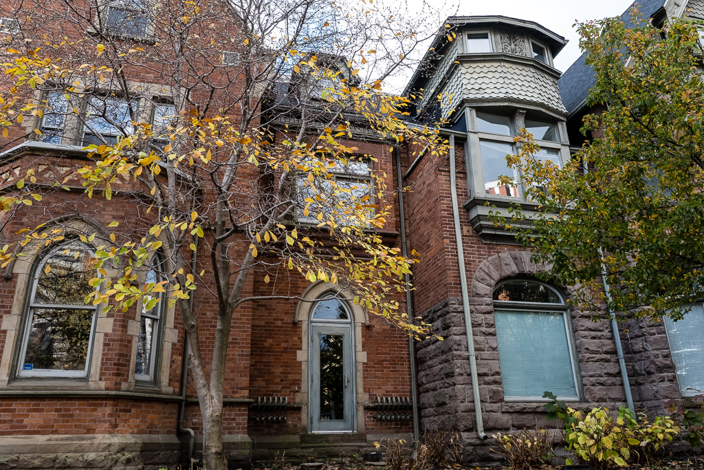
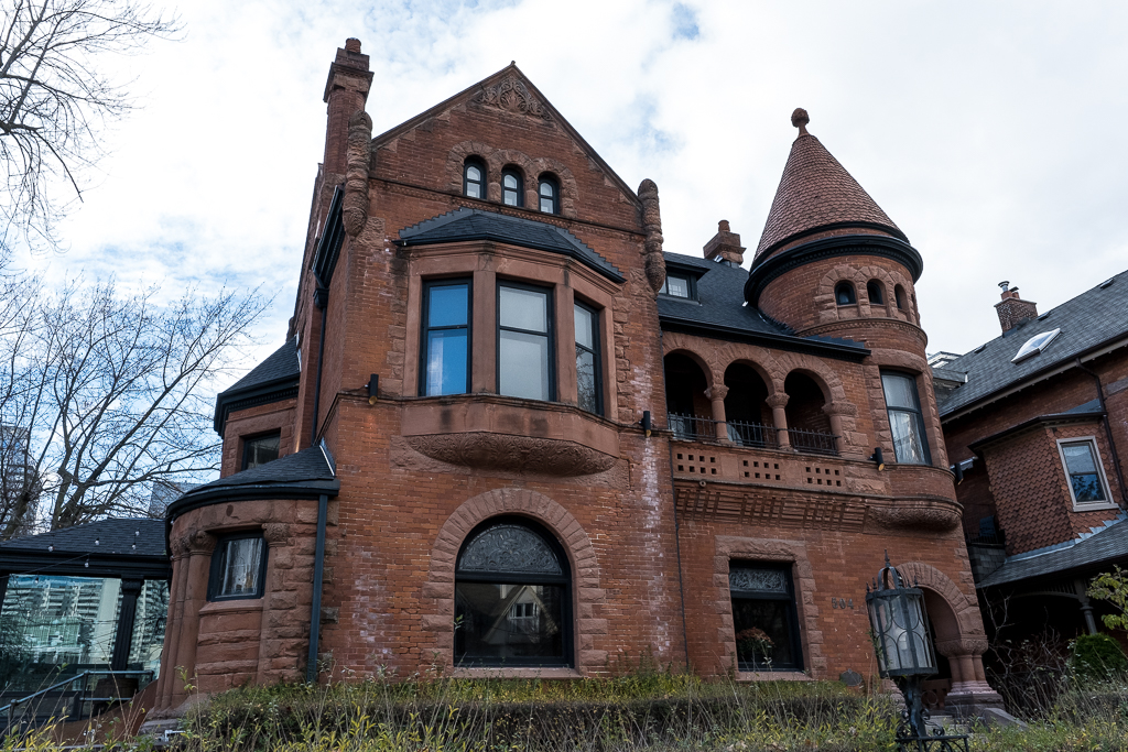
504 Jarvis Street G.H. Gooderham House
This Richardsonian Romanesque house was built in 1889 for George H. Gooderham. The Gooderham family owned the Gooderham and Worts distillery which dominated the waterfront, today known as the Distillery District. At least half a dozen family members owned mansions within a few minutes walk of George Gooderham’s new mansion.
The conical tower on one side is paired with a bald gable on the other end. Accents are cut from Credit Valley stone.
506 Jarvis Street
The building is known as the J.H. McKinnon House. Built in 1888 in the Queen Anne Revival style, the house is now a heritage property. It was designed by architects Langley & Burke, who created several other impressive Toronto residences back in the late 1880s.
510 Jarvis Street
Thomas B. Taylor had the house at 510 Jarvis built in 1888. Taylor had been involved in three paper mills along the Don River including one at Todmorden Mills. The building now consists of luxury apartments (rentals).
512 Jarvis Street The Gallows House
The Edward Gallow House was built in 1889-90 by E.J. Lennox, the renowned architect who designed Old City Hall and Casa Loma.
When researching this building I was very surprised to learn that the Victorian mansion is now a shelter providing refuge for homeless women. Entitled Mary Sheffield House, it was transformed to a shelter via a joint effort by Fred Victor, a social services organization for homeless and low-income people in Toronto, and the owners of the property, Mike and Giulia Ahmadi. The building is named after Mary Sheffield, who founded a downtown mission to help the poor and destitute, and battled the social problems that plagued Toronto in the late 19th Century.
Prior to its incarnation as the Mary Sheffield House, the building was inhabited by sixteen Jesuit priests for 20 years.
514 Jarvis Street The Rundle House
The Rundle House was built in 1889-90 also by E.J. Lennox. Built in the Queen Anne Revival style and named after Charles Rundle, one of its owners, The Rundle House has been described by Heritage Canada as one of the most important historical properties in the country. It’s currently used as a residence. The building is the end unit of one of the few intact sections of 19th century Jarvis Street.
The Rundle House was derelict by the 1970s, unheated and deserted. The city took it over in the 1980s. Then it was purchased by Virgin Records and they used it as a sort of haven for musicians who could lodge there and use it as rehearsal space.
While researching this building, I found the following interesting bit on the real estate site loopnet.com:
The three storey, 7,567 square foot building consists of 12 guest rooms, a kitchen/dining area, a living room, a recording studio and a small coach house at the rear of the property. Interior finishes are modernized while retaining historic features. The landscaped corner site of rectangular shape has frontages of 75.2 feet on the west side of Jarvis Street and of 150 feet on the south side of Gloucester Street.
515 Jarvis Street The Keg Mansion aka Euclid Hall
Designed by architect William Young in the Gothic Revival style, the building was completed in 1868 for businessman William McMaster. In 1882, it was purchased by Hart Massey of the prominent Massey family who built the agricultural equipment firm Massey Ferguson.
In 1915 the home was bequeathed to the University of Toronto’s Victoria College. It was an art gallery in the 1920s, then a restaurant named Julie’s Mansion, with the Bombay Bicycle Club on the top floor.
The mansion, also known as Euclid Hall, was designated as a heritage property in 1973. The building is rumoured to be one of the most haunted in Toronto.
519 Jarvis Street Chester D. Massey House aka Massey Mansion
519 Jarvis Street is a Toronto heritage building known as the Chester D. Massey House, or alternately, The Massey Mansion. Erected in 1887 by architect E.J. Lennox and renovated most recently in 1907, this official heritage structure stands as the picture of historical elegance along Jarvis Street. The Massey Mansion has an elegant stone arch and entryway, paired with an attractive red brick exterior.
This estate was the childhood home of brothers Raymond and Vincent Massey of the Massey Ferguson farm machinery family. Raymond (1896-1983) grew up to be a movie star, best known for playing Abraham Lincoln on stage and screen. He lived here in this family mansion from 1865 to 1915. Vincent Massey was the first Canadian Minister to the United States, the first Canadian-born Governor General of Canada and the founder of the Canada Council.
571 Jarvis Street The William R. Johnston House
Now Casey House, this building was designed by the architecture firm Langley, Langley & Burke in 1875 for William R. Johnston, a prominent Toronto clothing merchant. At the time, Jarvis Street was lined with large homes owned by the city’s wealthiest residents. The house remained in the Johnston family until 1941 when it became the national headquarters of the Young Women’s Christian Association (YWCA).
In 2001, the HIV/AIDS hospice Casey House bought the property. Casey House was the first independent HIV/AIDS hospice in Canada – and one of the first in the world – when it opened in 1988 on nearby Huntley Street. It provided compassionate, specialized care at a time when many people with HIV/AIDS faced isolation and discrimination. Casey House‘s services evolved and it became an HIV/AIDS hospital in 2016. in 2017, it moved to the renovated and expanded William R. Johnston House. The addition at the rear was designed by Hariri Pontarini Architects with ERA Architects, greatly expanding the capacity of Casey House.
This building is designated under the Ontario Heritage Act, 2002.
Having worked our way almost to Bloor Street East, our tour of historic Jarvis Street buildings comes to a close. If you’re still reading this rather lengthy post, I thank you for sticking with it to the end!
If you’d like to read more about some of the buildings I’ve mentioned, check out this link to The Mansions of Jarvis Street, which I’ve used as reference for some of the buildings listed in my post.
A private road north of St. Joseph Street, west of Bay Street, is home to red brick Edwardian style mansions that were built in 1892 by Remigius Elmsley as the first subdivisions in the City, located on the former family home, Cloverhill Estate.
The heritage properties are owned by University of Toronto, St. Michael’s College, some serving as student residences. The four houses of residence collectively contain 20 single and 12 double rooms. The buildings underwent a $4 million renovation in 2007.
The remaining houses are used as administrative offices: Founders House (1 Elmsley); Phelan House (3 Elmsley); and Windle House (5 Elmsley).
Developed during the 1890s, Elmsley Place attracted professionals and politicians, including Sir George W. Ross, who lived at No. 1 Elmsley while serving as Ontario’s premier. After the Supreme Court of Canada presided over the extension of present-day Bay Street northward during the 1920s, the college purchased the title to the street. By the late 1940s, the laneway was closed off and the Edwardian-style homes were converted to offices and student residences. Today, cut off from traffic, this tree-lined cobblestone lane is a perfect walk into the heart of the St. Mike’s campus.
The Gates of Elmsley Place A gateway across from the John M. Kelly Library on St. Joseph Street marks the entrance to Elmsley Place, a laneway that was once a prestigious late-Victorian subdivision. The Elmsley family were major 19th-century landowners whose holdings included what became the original campus of St. Michael’s College and the current Bay Cloverhill neighbourhood.
Founders House, 1 Elmsley Place Formerly known as the Sir George Ross House. Sir George Ross was, at various times, a professor, member of parliament, senator, provincial Minister of Education, premier of Ontario, and president of the Canadian Authors’ Society.
McCorkell House, 2 Elmsley Place McCorkell House operates as furnished female student dormitories
McCorkell House, 2 Elmsley Place McCorkell House operates as furnished female student dormitories
Phelan House, 3 Elmsley Place Phelan House was originally called the William E. Chalcraft House
Windle House, 5 Elmsley Place Previously known as the H. Hartley Dewart House. The late H. H. Dewart was a former provincial Liberal leader.
Brennan Hall, South Entrance The Hall is situated on the north end of Elmsley Place, 81A St. Mary Street
Maritain House, 6 Elmsley Place This house contains furnished male student dormitories
Gilson House, 8 Elmsley Place This is the only home on the street which St. Michael’s College does not own.
On the charming little downtown street known as St. Nicholas Street, house numbers 45 to 63 are known as “The Cottages”.
In 1883, The Scottish Ontario and Manitoba Land Company built ten row houses on the east side of St. Nicholas Street and named each cottage after a tree: Beach, Birch, Spruce, Hazel, Rose, Maple, Ash, Ivy, Elm and Oak. The properties were occupied by tenants, with occupations ranging from Saloon Keeper to Minister. The style of construction was Bay-N-Gable on a 18′ 10″ wide lot. These buildings have been designated under Part V of the Ontario Heritage Act. A little alley called Cottage Lane provides access to the rear of the houses.
45 St. Nicholas Street Beech Cottage and Birch Cottage
49-51 St. Nicholas Street Spruce Cottage and Hazel Cottage
53-55 St. Nicholas Street Rose Cottage and Maple Cottage
57-59 St. Nicholas Street Ash Cottage and Ivy Cottage
61-63 St. Nicholas Street Elm Cottage and Oak Cottage
A rare example of a surviving Victorian terraced row, 45-63 St. Nicholas Street is unique to say the least. The street sits just several hundred metres from Yonge and Bloor Streets, yet feels like a quaint neighbourhood block. St. Nicholas Street was, in fact, originally an alley lane before the row was constructed in 1884.


Yes, it needed To go. I lived nearby and would pass this hospital many times over the years. Looking forward…